6 First Alert Forecast - Summer heat lasts through the week
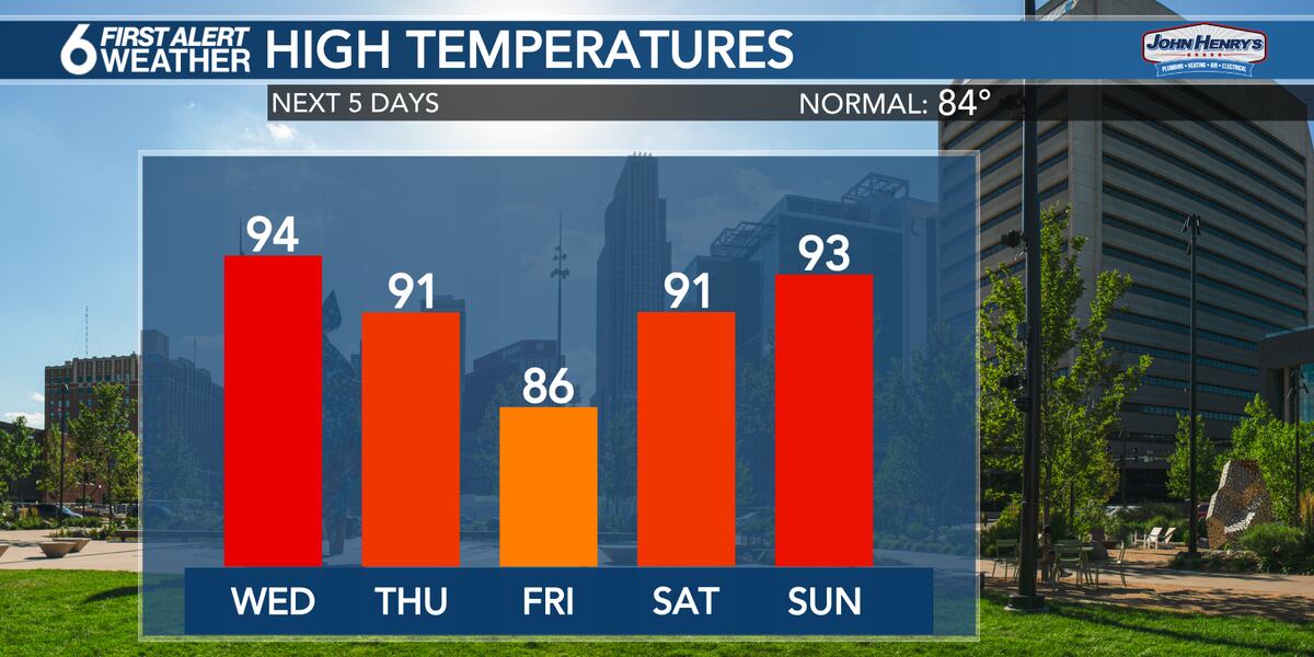
Summer heat and some humidity continue to build this week, with storm chances by the weekend. The first round of hot and humid weather is expected for the week, with temperatures expected to reach around 90 degrees in Omaha, marking the first official 90 degree day of year for Omaha. Despite a few clouds and a few sprinkles moving out of the area, temperatures quickly rose to 90 degrees. The humidity should remain high throughout the day, with highs expected to remain around 90 while temperatures will drop into the mid-60s by early Wednesday morning, with more humidity expected. Despite this, a weak cold front is expected to move through the area to lower humidity levels, but temperatures are expected to continue to rise. A more active, stormy weather pattern is expected beginning on Friday and lasting into next week, potentially leading to rain every day from Friday through at least Monday or Tuesday.
Được phát hành : một năm trước qua David Koeller, Emily Roehler trong Weather
OMAHA, Neb. (WOWT) - A few clouds and a couple of sprinkles quickly moved out of the area this morning, leaving sunshine and quickly warming temperatures. The first round of a stretch of hot and humid weather moved in for the afternoon, with highs climbing to around 90 degrees. This marked the first official 90 degree day of year for Omaha, though some areas have hit 90 degrees earlier in the season. Thankfully, the humidity dropped a little for the afternoon hours but it is certainly higher than it has been for the past few days. Temperatures will hover around 90 degrees through at least 6pm, dropping back into the upper 70s by 10pm.
Overnight conditions should be calm and comfortable. Temperatures drop into the mid-60s by early Wednesday morning, with a little more humidity in the air compared to the past several days. The humidity will be noticeable through the day, though it shouldn’t get too terribly thick, at least not yet. Plenty of sunshine is expected throughout the day, leading to quickly climbing temperatures. We should be in the upper 80s to near 90 degrees by Noon, with afternoon highs in the low to mid-90s across the area. Winds will become a bit breezy for the afternoon hours, coming in out of the southwest with gusts up to 30mph.
More hot weather is expected on Thursday. The morning hours may be especially muggy, with higher humidity levels moving in before sunrise. However, a weak cold front is expected to move through the area by midday. This front will switch winds to the north and help to lower humidity levels a bit. Despite the front moving through, very warm conditions are still expected. Highs should still top out around 90 degrees for the Omaha metro, with even warmer conditions across southeast Nebraska and far southern Iowa where it will take a little longer for the front to push through. Temperatures may be a few degrees cooler on Friday, but the 90s should quickly return for Saturday and Sunday, along with some higher humidity.
Humidity levels shouldn’t be too high for Wednesday and Thursday, but we could still see heat index readings in the low and mid-90s as times. By the weekend and early next week, higher humidity levels will likely result in the heat index climbing into the mid and perhaps upper 90s at times.
A more active, stormy weather pattern is set to move in beginning on Friday, and lasting into next week. The first of several rain chances should arrive late Friday evening, or more likely Friday night into Saturday morning. Severe weather is not expected at this time, though heavy rainfall is likely with any storms. Additional storm chances are in the forecast for Saturday evening and overnight, as well as Sunday night and Monday night. Not everyone will see rain with each of these chances, but there will likely be rain in the area just about every day from Friday through at least Monday or Tuesday of next week.